


Waterkaarten
Boat Navigation
Description of Waterkaarten: Boat Navigation
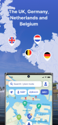
Waterkaarten is a navigation app specifically designed for boating enthusiasts. This app provides essential tools and resources to assist users in safely navigating waterways across five countries: the United Kingdom, Netherlands, Germany, France, and Belgium. Available for the Android platform, users can easily download Waterkaarten to access its various features that enhance their boating experience.
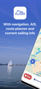
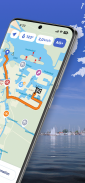
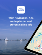
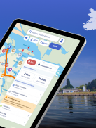
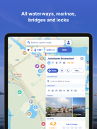
The app serves as a comprehensive guide for those navigating on water, integrating route planning, real-time information, and offline capabilities. Users can plan optimal routes between their starting points and destinations while taking into account various nautical objects they may encounter along the way. The app includes detailed information on over 200,000 nautical objects, which encompass bridges, locks, markings, and mooring places. This extensive database helps users make informed decisions during their journey.
Waterkaarten also provides up-to-date information regarding marinas, bridges, and locks, including their opening times. This feature is essential for boaters who need to coordinate their travels with the operational schedules of these structures. Additionally, the app enables users to show or hide specific information on the nautical maps, allowing for a tailored experience based on individual preferences and navigational needs.
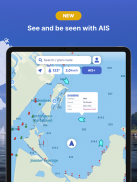
A significant addition to Waterkaarten is the AIS pairing functionality. This feature allows users to connect their AIS (Automatic Identification System) devices to the app, facilitating the tracking of surrounding vessels. This capability enhances situational awareness, which is crucial for safe navigation on busy waterways.
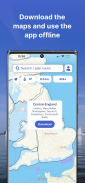
For those who may find themselves in areas with limited connectivity, Waterkaarten offers offline use by allowing users to download the necessary nautical charts. It is advisable to download these charts while connected to a stable Wi-Fi network due to their large file sizes. This offline capability ensures that boaters can access critical navigation information even without an internet connection.
The app keeps users informed with current navigation reports and any obstructions from the Rijkswaterstaat, the Dutch government agency responsible for water management. This timely information allows boaters to adapt their routes as necessary, ensuring a safer journey.
Waterkaarten is available on a subscription basis, providing a free trial for the first seven days. After this period, users can choose from several subscription options, including monthly, seasonal, and annual plans. The subscription process is straightforward, and payments can be made through various methods, including credit cards and PayPal.
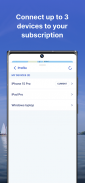
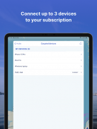
Users can create a Waterkaarten account, which allows for the activation of subscriptions on multiple devices, up to three. This feature is particularly useful for boaters who may use more than one device during their outings. The app also receives regular updates, ensuring that users have access to the latest features and improvements.
The app's user interface is designed to be intuitive, making it accessible for both novice and experienced boaters. The straightforward navigation through the app's features allows users to quickly find the information they need without unnecessary complications.
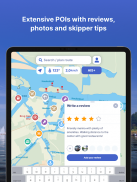
In addition to its navigation capabilities, Waterkaarten provides access to almanack information, which includes a wealth of details relevant to boating and navigation. This information is accessible with just a few taps, making it convenient for users to gather the necessary data for their trips.
As users navigate their chosen routes, they are encouraged to remain vigilant and aware of their surroundings. While Waterkaarten serves as a valuable aid in navigation, it is essential for boaters to stay alert and prioritize safety on the water.
The app's focus on providing detailed nautical information, real-time updates, and customizable map features makes it a practical tool for anyone involved in boating. The combination of offline access, AIS pairing, and extensive databases of nautical objects ensures that users are well-equipped for their journeys.
Waterkaarten is designed to enhance boating experiences by offering essential navigation tools and timely information. By downloading Waterkaarten, users gain access to a wealth of resources that can significantly improve their boating adventures.
For more information about the app, you can visit their website at www.waterkaarten.app/en or contact their helpdesk at support@waterkaarten.app.
Waterkaarten: Boat Navigation - Version 11.12.1
(20-03-2025)Waterkaarten: Boat Navigation - APK Information
APK Version: 11.12.1Package: nl.anwb.android.anwbwaterkaartenLatest Version of Waterkaarten: Boat Navigation
Other versions


 3.79
3.79

Apps in the same category


